Taubman College Fellows explore boundaries, thresholds, and ‘Rough Cuts’ in 2025 exhibition
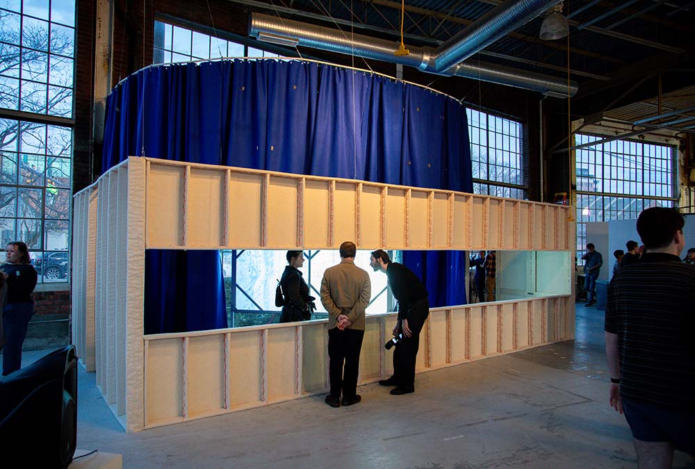
The 2025 Taubman College Fellows Exhibition invited visitors to step through unfinished thresholds and across uncertain boundaries into spaces that are ever changing. Held in the Liberty Research Annex and Gallery, the exhibit featured work by five recent members of the Taubman College Fellowship Program, concluding with a reception in March that included talks by each of them.
Fellows Ryan Ball, Olaia Chivite Amigo, Angela Cho, Tess Clancy, and Francesca Mavaracchio produced work that explored doors, borders, totems, and vessels that form boundaries. They sought to discover the uneven cuts that shape how we move, see, assemble, and belong.
More than 100 fellows have completed the Taubman College Fellowship Program since it began in 1984. The fellowship program serves as a conduit for innovation and a bellwether of cultural changes in the architectural industry. The influence of this elite network radiates across the U.S. and worldwide. To date, approximately 20 former fellows have remained at Taubman College, where they are now permanent faculty members.
More on the projects from the fellows is below.
Structure, Control, Cladding
Ryan Ball
“Structure, Control, Cladding” explores the tectonic, environmental, and political consequences of the U.S. adoption of the rainscreen. I argue that the rainscreen’s ideological separation of aesthetics and performance has had far reaching consequences beyond just tectonic legibility. It invisibilizes labor, care, repair and maintenance, and among other factors, homogenizes expectations of comfort while promoting consumption, fully isolating users from their natural environment.
In the gallery, the work presents as a spatial mass of three separate nested volumes (circle, square, and diamond) with each corresponding to the layers of the rainscreen (structure, control, and cladding.) Conceptions of interiority and exteriority are problematized, and visitors are called to confront their expectations of comfort, juxtaposing material and formal familiarity with visualizations of an increasingly changing climate.
Borders
Olaia Chivite Amigo
Borders are more than fixed lines — they are dynamic territories shaped by political, economic, and environmental forces. This project explores the U.S.–Canada border as a space of negotiation and transformation rather than a static divide. Focusing on six key regions — Maine/New Brunswick, Niagara Falls, Detroit/Windsor, Boundary Waters/Quetico Park, the Bakken region of Montana and Saskatchewan, and the Columbia River of Washington and British Columbia — it examines how borders are enforced and experienced over time.
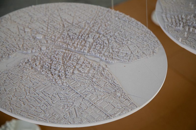
Through mapping, territorial analysis, and narrative construction, the work reveals the fluidity of borderlands. From east to west, each site reflects distinctive strategies — regulatory, cooperative, or contested — through which these territories are shaped and reshaped.
In Maine–New Brunswick, land ownership and power are concentrated in a few families, cinching control over labor, production, and land stewardship. Niagara Falls thrives on tourism but is governed by strict regulations controlling water and power on this natural wonder. Detroit and Windsor, home to the busiest land border crossing in North America, are deeply intertwined through trade, industry, and culture. Quetico Park presents a nearly invisible “perforated” border within protected wilderness. The Bakken region is a transboundary oil landscape shaped by extraction, infrastructure, and labor. The Columbia River is managed by treaties that govern water, energy, and Indigenous rights.
The U.S.-Canada border — often perceived as a single demarcated line — is a living, evolving territory shaped by political, economic, and environmental forces. This project reconsiders it as a living system, shaped by movement, conflict, and cooperation. It offers new ways of seeing and understanding these borderlands as layered, evolving, and deeply human territories.
Angela Cho
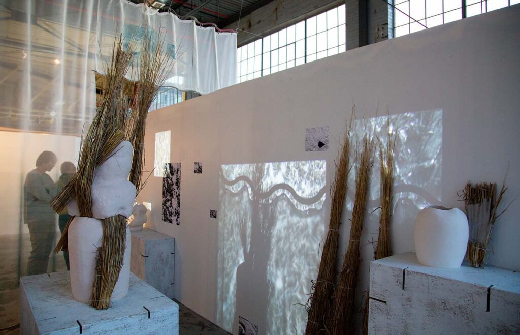
Cho’s work is highly manual, abundant in plaster and clay, and grapples with philosophies and techniques of memory, preservation, scale, tactility, originality, and experiential sequence.
Documenting Demolition
Tess Clancy
Documenting Demolition examines the impact of Detroit’s demolition program, which began in 2014 with the goal of removing 40,000 blighted properties, many of them single family homes. While the demolition of these homes is often accepted as a necessary step forward, this project questions the true motivation for demolition and reflects on how memories and culture connected to the homes can still be preserved. The exhibition includes the documentation of houses slated for demolition, treating them with historical significance through detailed drawings that honor their architectural value and the stories of their past residents. This preservationist approach shifts the narrative from that of market-driven urban renewal to one that emphasizes the importance of memory and community history. How does one memorialize or monumentalize a home?

The design of object-specific display armatures for elements salvaged from demolition sites raises critical questions about material value and salvage, and the possible future of deconstruction, questioning the necessity for demolition and the potential for diverting demolition material from the landfill. Through lidar imagery, drawings, models, and the display of salvaged elements, Documenting Demolition engages viewers in a dialogue about experimental preservation and memorialization in Detroit’s residential neighborhoods.
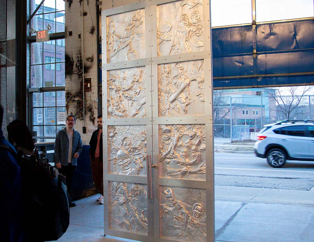
Doors
Francesca Mavaracchio
Doors is a project centered on a large door, inspired by classic medieval bronze doors and depicting contemporary iconographies. The work consists of an 11-foot-tall, two-panel door with an aluminum frame and eight gilded wood bas-reliefs. The design reflects the door as both a physical threshold and a symbol of transition and change. The bas-reliefs draw from protest imagery from 2020–2022, building on the idea of constructive interference and exploring how repetition creates significance and meaning in visual language.