Mapping injustice, charting a path toward repair
Associate Professor Robert Goodspeed and students help uncover racially restrictive covenants in Michigan
A massive collaborative research project, including work by Taubman College faculty and students, helped uncover more than 9,000 racially restrictive covenants in Michigan’s Washtenaw County, which have been published as part of an interactive online map and accompanying toolkit to help homeowners and neighborhoods repeal them.
Justice InDeed published the map last fall, when it also hosted a series of community shareout events at Taubman College, Ypsilanti District Library, and Ann Arbor District Library. The community collaborative, comprised of University of Michigan faculty, staff, and students, along with local community organizers and residents, led the five-year project, enlisting more than 1,000 volunteers to help.

Robert Goodspeed, chair and associate professor of urban and regional planning, a project participant since 2020, played a key role in the mapping phase completed last year. Other key U-M participants were Michael Steinberg, professor from practice and director of the Civil Rights Litigation Initiative at U-M Law School; Justin Schell, director of digital scholarship and creative spaces at U-M Library; Hillary Poudeu Tchokothe, A.B. ’26; and U-M Law students Edward Madrigal and Johnathan Johnson.
Yodit Mesfin Johnson and Jessica A.S. Letaw from Future Root, a community-centered design and strategy lab based in Ann Arbor focused on addressing racial injustice in land use planning and fostering community engagement, led the two-year community-engaged mapping process in partnership with the U-M participants. Goodspeed also recruited students to help with research, including the incoming M.U.R.P. class of 2026, who attended a transcription session as part of their orientation at the college.
“These covenants shaped where people could live, excluding Black families and others from neighborhoods across the county,” Goodspeed says. “Their legacy is still with us.”
Starting in the early 1900s, restrictions added to deeds across the county forbid mainly Black families, as well as other racial, ethnic, and religious groups, from living there. While these bans are now illegal, they were used to segregate the county in the 20th century and still exist in property records today. Until the Supreme Court ruled in 1948 that the restrictions could not be enforced, courts throughout the U.S., including Washtenaw County Circuit Court, voided sales of homes to Black families. The majority of covenants discovered were found in deeds of homes built between 1920 and 1950, but some dated as far back as 1900 and as recently as the 1960s.
Volunteers devoted more than 5,000 hours to the project, transcribing approximately 12,500 property records suspected of including racist covenants. Documents were provided by the Washtenaw County Clerk/Register of Deeds. During the Ypsilanti shareout event, organizers and volunteers spoke about the importance of uncovering the truth and what participating in the project meant to them, personally.
“I think about what it means to reclaim belonging and to tell the truth about what’s happened, not for shame and blame, but so that we can imagine what might be possible,” Mesfin Johnson said. “It matters because justice begins with memory. It begins with remembrance as a radical act, and I believe it can transform grief into grounding and knowledge into power.”
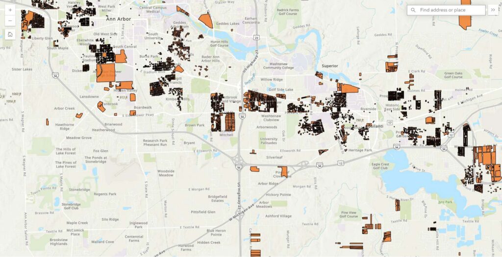
In addition to the map, Justice InDeed also published a do-it-yourself “repeal toolkit” to help property owners remove racist restrictions. Site visitors can search the map to determine whether their property has racial restrictions, then use that information to fill out a template that repeals them and adds protections against future discrimination, which they can then file with the county. The project’s map is included in the City of Ann Arbor’s Comprehensive Plan, and the team is now turning to efforts to use the map and data to contribute to conversations about reparations, regional equity, and affordable housing in Washtenaw County.
The project joins a consortium of efforts to expose racist covenants and repair harms caused by them across the U.S., including in Washington, Minnesota, and North Carolina.
Explore the interactive map and other projects at Justice InDeed.
— Eric Gallippo
Main Image Caption: Yodit Mesfin Johnson (right) and Hillary Poudeu Tchokothe present during a community shareout event at Taubman College. Photo by Johnny Lee.